thegreenergrassfarm
Land Management Through Sustainable Farming
Menu
Tag Archives: grazing
Calculating Fencing Costs
Full digitization of fence lines and posts in GIS software makes the basic calculations simple. GIS provides geometry of the digital features including fence length:
Total Length of Permanent Fencing
(In “Sum” field)

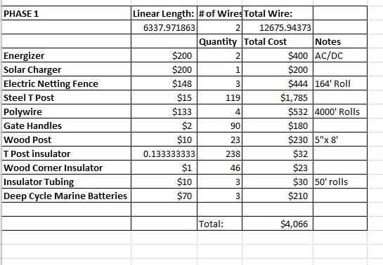
Also determined by GIS, I have 26 wooden corner posts and 162 steel line posts in the full phase fence plans. Breaking it down to Phase 1-only shows a need of 23 wood and 119 steel posts.
Those figures alone let me derive most of the other materials needed in simple excel formulas. For example, each wood post requires insulators for both the spark and ground wires, while the leaving the steel posts uninsulated to the ground wire acts to ground it! However I am still trying to research if it is desirable to only leave the steel posts uninsulated at specific intervals. I am also debating if I need to install a gate at every paddock. For now the last question is factored in as affirmative.
For Phase 1 Fencing:
Now with 3 wires added for phase 2 plans, the calculations are as follows:

Other than buying the animals themselves, this should be the biggest investment I have to make!
Fencing Phases
Goats are awesome and I require a few on any farmstead operation I undertake. They are fun, have a lot of personality and provide awesome milk! I only want enough to provide milk and occasional meat to myself. However they are also quite adventurous and have a reputation for escape artistry. Consequently, fencing matters are complicated by goats.
Ideally I would like to run the goats and cows together to reap the benefits of multispecies farming. The goats will remove woody and broadleaf plants from the pasture while cattle turn the solar energy capture by grasses into protein! Since the pasture has been unmaintained, there will be plenty of work for the goats whose salary will be a feast of heavy populations of immature trees and brushy areas.
Fencing will be done in two phases. Phase 1 will serve the needs of permanent and temporary fencing for the cattle while providing the goats with their own movable electric net fencing. At lease the cattle will trample whatever plants they don’t like but I would like to let the goats harvest that biomass. The major difference with Phase 1 alone will be that the permanent electric fences contain only 2 wires. One or two wires will be use for the temporary paddock boundaries.
Phase 2 will accommodate the mixed goat-cow heard by upping the wire count to 5 (or more). The electric fence netting will be used as the temporary fencing for the mixed herd.
Eventually I would like to rebuild the permanent parameter fence for a big of escapee containment insurance.
My main concern is predation of the goats when separated from the cattle…and even when the herds are mixed. If coyotes prove to be an issue, we can have a vote when the time comes: llama, donkey, mule, guardian dog?
Mapping the Fence Posts
Lucky for me, there is a built-in tool in GIS software that allows points to be added along lines. I’m going to go ahead and add the points then make modifications to the fence line and posts together.
Constructing Posts:

Based on recommendation from fence vendors and manufacturers, I want the distance between posts to be no greater than 45 feet. Since I have to chose units in the same coordinate system I am using (State Plane), my input is 16 meters (~40 ft). In the “Construct Point” tool, I choose to create points based on the desired interval, not a total number of posts. Clearly you need posts at the start and end of the fence so that option is selected as well:

The fence posts will now be outputted to the blank point shapefile in which it was directed. Keep in mind that these are only the permanent fence posts!
For electric fencing, I want well-anchored wooden post for corners and galvanized steel for the line posts. The galvanized posts have an additional benefit of acting as grounding rods for the electric fence system while the braced wooden posts keep everything secure. Symbolized wood/steel posts, cleaned up fence lines and cleaned up post points yield the next iteration of my fence map:

Calculating Cattle Needs
In my previous post, I decided to start with a paddock size of 5,000 square feet. Joel Salatin at Polyface Farm has recommended in the past to use 200 square feet per cow-calf pair per day.
I adapted that figure to 300 square feet per pair per day as the pasture I will be using has been unmaintained for about a decade. So until I see how much the cattles graze, I am going to be very conservative. The beauty of Managed Intensive Rotational Grazing (MIRG) is that I can easily change on the fly if required.
So theoretically, each daily-use paddock: (5,000 ft^2) / (300 ft^2/pair/day) means I can support 16 and 2/3 cow-calf pairs a day.
I made an interactive spreadsheet to automate these calculations for different scenarios, but I will save that until I dig more into the economics of cattle.

Determining Paddock Needs
While technology is often is a distraction and detraction to satisfaction, it provides invaluable tools. My planning will be done through Geographic Information Systems (GIS) to maximize performance and efficiency of the farm operation.
Calculated Square Footage: Top Row is with Trees Removed

Instead of basing my calculations off of stocking rates and head of cattle, I am going to use the amount of land available.
Through much trial and error, I was determined to find a paddock area that would yield 40 individual paddocks. Complicated by removing trees from my pasture data, I could not simply divide my total area by 40 (although parcel editor seems to be able to accomplish this even though I could not get it to work). So the production process consisted of cutting, merging and various other GIS processes as well as running a python command. Here it is for any other GIS users out there:
arcpy.CalculateField_management(“Pasture_Boundary”,”Acreage”,”!shape.area@squarefeet!”,”PYTHON”)
The python command re-calculates the area of the paddocks in square feet.
In the end, I found that 5,000 square foot paddocks produced 45 ugly-shaped but usable paddocks. Remember that grass growth factors rely on climatic variables. The truth is that grass may not regenerate quickly in a drought situation. So I want to give each paddock at least 30 days of rest with an option for 10-15 to accommodate potential drought situations. I designed 40 paddocks for cyclical use while leaving 5 open for the existing wildlife corridor to be used only if necessary.
Proposed Paddocks

Now it will be easy to determine fencing needs!
Brief Overview: Grazing Sciences
Cows are picky if given the opportunity to selectively graze. They will return to the most delicious grasses as soon as new growth appears while letting the less palatable (but equally nutritious) grasses reach maturity (thus no longer nutritious), seed and eventually crowd out the good stuff. With the Managed Intensive Rotational Grazing (MIRG) system, the animals are given the exact amount of pasture that they can eat in 24 hours before being moved to a fresh paddock which encourages the animals to take a more “mowing” approach opposed to selective. Each paddock is rested until it regenerates.
Grass grows on an “S” curve as demonstrated by this excerpt from the California Grazing Association’s publication titled Principles of Controlled Grazing (PDF):

Since I am working with so little land (~6 Acres with trees removed), I want to manage it as efficiently as possible. The next question is how much do I let the grazers mow the paddocks? According to these fantastic demonstrations on Forage Decision Aids by the University of Kentucky, we can directly compare the regeneration of Orchard Grass of the 6 days following simulated grazing to 3.5 inches vs mowed all the way down to 1″.

Combined with various different university studies, most grasses regenerate best when grazed to ~10 cm. At this length, grasses retain enough photosynthetic tissue to create the energy required for regrowth without having to use reserves stored in the root system.
Mapping the Farm!
My first step to analyzing the viability of my pasture was to produce a digital map. I grabbed some high resolution imagery and drew the boundaries, otherwise known as digitizing or interpreting aerial photography in the Geographic Information Systems (GIS) industry. After digitizing the pasture, an array of powerful tools are opened up to me to perform geospatial analysis.
Base Aerial Image

Boundaries Drawn for Pasture

As you can see, pioneer species of trees have popped up sporadically. I’ve decided to work with them rather than against them as they have created wildlife corridors for deer. However I understand that I cannot consider the area beneath the trees as good grazing material. So my next step was to digitize the trees in GIS software, then cut them out of my pasture polygon.
Pasture with Trees Removed

Geometries like area, perimeter and anything else needed can be instantly calculated:
Acreage of Pasture (top is with trees removed)

With these basic data creation steps complete, I can move forward with more advanced analysis to plan the farm. Stay tuned!
Please don’t hesitate to leave comments if you catch any errors in my methodology, can offer feedback, have questions or would like me to perform similar GIS analysis for your property!
Get every new post delivered to your Inbox.